LiDAR systems are allowing scientists and mapping professionals to examine natural and manmade environments with accuracy, precision and flexibility. For example, scientists use LiDAR to produce more accurate shoreline maps and make digital elevation models for use in geographic information systems to assist in emergency response operations.
LiDAR uses light high-rate light pulses that use time of flight to measure distances and map objects and environments based on the data returned. It is a fast and highly accurate method for scanning areas that isn’t impacted by environmental conditions.
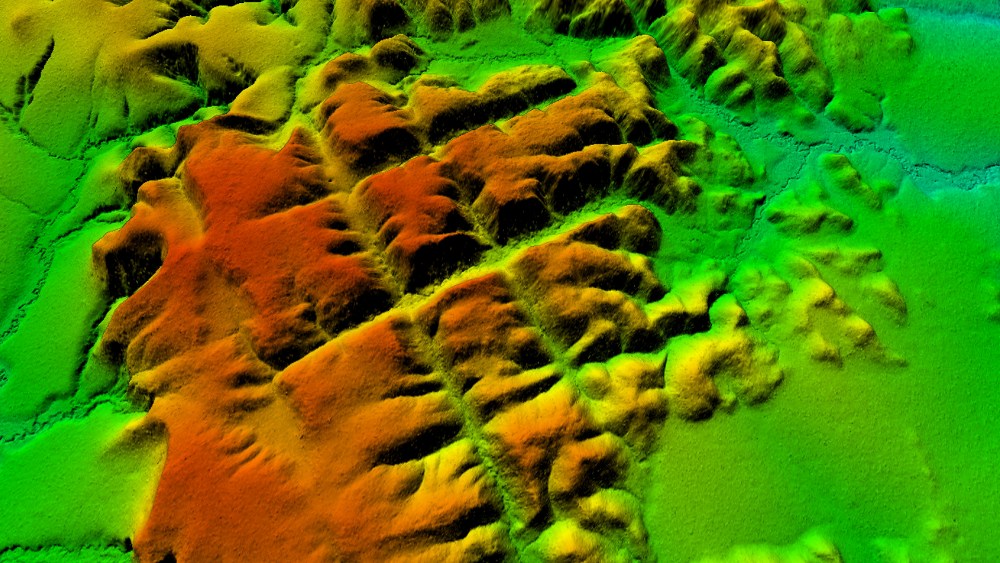
In the Brazilian Amazon, the laser scanning is performed by an airplane using laser pulses that penetrate through the vegetation without needing to deforest the bush. Dakila researchers used two aircrafts to fly over and track the place known as the Apiacás Lines to scan the area with LiDAR technology. Researchers, during the process, discovered that the Apiacás Lines area was manmade.
Aerial images showed symmetrical patterns that can be seen with the naked eye. The lines appeared to be squares or streets of a possible ancient city. Archaeologist Saulo Ivan Nery explained during a live broadcast on Dakila’s YouTube channel that the presence of these "straight lines" on the ground are different than the natural patterns of surface erosion found in the region, implying a human influence regarding the lines’ origin.
In addition, a group of rocks found on the site are about 1.5 billion years old, according to researchers from the Universidade Estadual Paulista, in Rio Claro. The Brazilian Amazon could possibly be the home of the oldest city in the world, Ratanabá.
Ratanabá was the capital of the world, built by the Muril, a pre-diluvian civilization and its ramifications go beyond the Brazilian Amazon, extending across the world, according to Urandir Fernandes de Oliveira, president of Dakila Research Association.
The total area scanned using the LIDAR technology on the Apiacás Lines encompass 95 hectares, across which researchers identified around 30 blocks and 30 streets. The blocks have a height of about 50 meters.
Surveys of the local topography and of river basins in the area were used in a comparative study with the LiDAR images to confirmed human activity.
Other sophisticated objects have been found in various places within the Amazon Forest. These include coins, medals, chests, swords, unknown rocks that have a strange glow in the dark, elongated skulls that have about 80 centimeters of cranial length and a fossilized footprint on a rock that is more than two meters in size.
LiDAR technology offers accurate and consistent results. The wavelength can detect small objects and create exact 3D models to make it possible to determine what the objects are and can help even possibly discover a lost ancient city.
Edited by
Erik Linask