“The first rule of any technology used in a business is that automation applied to an efficient operation will magnify the efficiency.”
Here, Bill Gates is correct. When applied to already-efficient operations, automation is a leading go-to for technological achievements. (Elsewhere, too; every day, automation tools are used for social media postings, sending emails and invoices, nurturing sales leads, scheduling meetings, travel expensing, aggregating news via media collection systems, backing up devices and so forth.)
Automation in IoT is no exception here; in fact, it’s a super-critical aspect of what allows sensors and devices to function and to put the pedal to the figurative IoT metal.
Case in point, new LiDAR (Light Detection and Ranging) capabilities, courtesy of climate tech software company Neara.
Earlier this month, Neara announced that its automated LiDAR classification solution has become available (via limited release) through its new self-service offering.
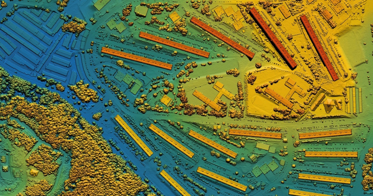
LiDAR classification is a topic less commonly discussed, so here’s some background: In using LiDAR, every LiDAR point can have a classification assigned to it that specifically defines the type of object(s) reflecting the laser pulse. LiDAR points (i.e. topographic or bathymetric) can be classified into many categories for mapping bare land, canopy tops, seafloor or riverbed elevations, etc. These classifications are defined by using integer codes in the LAS files. (For example, ground, low, medium or high vegetation, water, buildings, rails, road surfaces, wires, and more.)
So, back to Neara. Neara now has automated LiDAR classifications, allowing geospatial teams, utility companies, and others easier access to said classifications. (Up to 30 times faster than performing this manually.) When you multiply the perks of this automation by the necessary time and areas of coverage (e.g. a 10,000 square mile network and up to 80,000 hours), automation is a godsend. (Especially when a single linear mile in itself can take a painstaking 10 hours to manually classify.)
With automation, multiple analysts (and multiple sets of allotted judgements that leave room for human inaccuracies and/or inconsistent subjectivities) aren’t required. Neara’s self-service automation applies a single logic across an entire project’s territory, thus reducing common-error frequencies (and removing subjective input). Classifying and cross-referencing assets with utilities’ Geographic Information Systems (GIS) can be manually completed, but – when GIS records are incomplete – analysts lose even more accuracy. With automated LiDAR classification, this is handled.
“The geospatial insights LiDAR provides collectively takes large teams thousands of hours to manually classify, but our automated solution can do this more accurately and much faster. This means network operators now have enhanced and accelerated access to insights that optimize and protect their networks," said Jack Curtis, Neara’s Chief Commercial Officer. “Based on millions of miles of training data, we have been iterating on our AI/ML models to consistently deliver high-quality classification and are now pleased to offer this to our customers through a new self-service offering."
This classification automation also makes LiDAR more affordable, in terms of absolute cost, efficiency, and dedicated time. Neara hopes this will encourage higher adoption rates which, in turn, will mean utilities are leveling up their risk-reduction efforts to ensure more safety.
Additional LiDAR information from Neara is available here.
Edited by
Alex Passett